
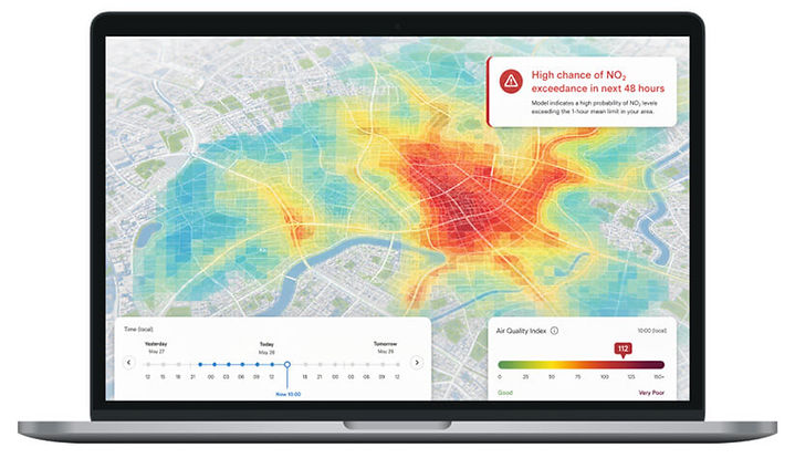

Monitoring tells you part of the story
Air quality changes street by street, hour by hour. Monitoring provides trusted measurements at specific locations, but it cannot show the full picture across every road, neighbourhood or area of interest.
MappAir® fills these gaps by modelling air quality where physical monitoring isn’t practical, providing continuous environmental intelligence between and beyond monitoring locations. By combining multiple environmental datasets with advanced atmospheric modelling, organisations can understand pollution patterns, forecast future conditions and identify what’s driving poor air quality.


Road Transport
Traffic emissions from cars, buses, HGVs and motorcycles across the road network.

Non-Road Sources
Shipping, ports, rail and other local sources that contribute to emissions.

Domestic Heating
Emissions from residential heating and solid fuel burning

Background Pollution
Regional and long-range pollution informed by wider environmental datasets
From environmental data to air quality intelligence
What Powers MappAir®?

High-Resolution Maps
Continuous air quality maps with historical, current and forecast views.

Forecasting
Predict air quality conditions up to 48 hrs ahead to support planning and operations.

Source Attribution
Understand the contribution of transport, industry and background pollution.

Data Integration
Deliver model outputs through APIs, GIS and data services

How MappAir® creates air quality intelligence
Environmental intelligence. Delivered
Atmospheric Dispersion Model
Weather and atmospheric conditions simulate how pollutants move, disperse and influence air quality.
Calibration & Validation
Monitoring data calibrates and validates model outputs, improving confidence in local air quality predictions.
Emissions Model
Transport, industry and other emissions sources are combined to create a detailed emissions inventory.
Supporting air quality decisions across sectors

Local Government

Industry

Construction

Schools & Communities

Transport
Support clean air strategies, public health initiatives and policy development.
Understand operational emissions and support environmental compliance.
Forecast dust impacts, assess mitigation and support planning compliance.
Understand local exposure around schools and vulnerable communities.
Support traffic management, operational planning and infrastructure decisions.
Supporting air quality decisions across sectors

Local Government
Track exposure, support policy decisions and monitor interventions.
Supporting air quality decisions across sectors

Industry
Monitor operational impact, emissions and compliance requirements.

Construction
Understand site impact, support planning conditions and monitor sensitive locations.

Schools & Communities

Transport
Forecast pollution episodes to help protect schools and vulnerable communities.
Evaluate transport schemes and understand emissions impacts.
Trusted by organisations delivering better environmental outcomes

Jacobs partnered with Essex County Council and EarthSense to monitor air pollution exposure around four schools using portable Zephyr® air quality monitors carried in specially adapted backpacks. Real-time pollution data was collected along school routes and visualised using MappAir® to identify local air quality hotspots. The project increased community awareness of the impact of transport choices on air quality, supported evidence-based decision-making, and provided valuable insights to help reduce pollution exposure around schools.

Westminster City Council used EarthSense’s MappAir® platform to assess the impact of School Streets initiatives at twelve primary schools across London. By combining air quality measurements, traffic data, diffusion tube monitoring, and historic pollution analysis, MappAir® enabled the Council to quantify changes in nitrogen dioxide (NO₂) concentrations and understand the relationship between traffic volumes, pedestrian activity, and air quality. The project provided robust evidence to support policy decisions and demonstrated how School Streets can contribute to cleaner air and healthier school environments.

One subscription, everything included
EarthSense solutions are delivered through our annual subscription, bringing together hardware, modelling, platform access, communications and ongoing support in one simple package. If your organisation requires a different purchasing approach, we’re happy to discuss the right solution for your project.